Back to top: Project's history: the Sites domain
PHASE II. PORTABLE COMPUTERS (1976-96)
Back to top: Project's history: the Sites domain
1976-81: Categorization
Openly inspired by the digital experiments with cuneiform texts, which had started some eight years earlier, our early years in Terqa served an important propaedeutic function for the later digital developments. Essentially, this was in terms of establishing from the start a categorization system that would be suited for a digital environment.
Emblematic of this approach was the publication, in 1978, of G. Buccellati and M. Kelly-Buccellati, IIMAS Field Encoding Manual (Non-digital), ARTANES 2. The emphasis on the “non-digital” aspect of the Manual indicated that we were aware of the importance of a digital approach, and that we meant the current system to serve as a transition to the new digital platform. We were, one might say, conceptually digital while preparing for a proper digital implementation. As we stated on p. 5, “… the system is intrinsically predisposed to computerization, since categories and codes are explicitly defined in terms of a comprehensive structural system.”
Back to top: Project's history: the Sites domain
1982-83: The first computers
In 1982 we brought to Terqa the first computer to be used in Syrian archaeology. The support of the Directorate General of Antiquities and Museums was indispensable in allowing us not only to bring the equipment to the site, but also in securing the proper conditions for its maintenance and effective functioning. The “micro-computer,” as it was then called, was anything but “micro,” except if compared to the enormous mainframe computers. It also required special attention, including a dedicated space that could be kept, in the absence of an air conditioning system, as cool as possible: a small dark room in the mudbrick house of the Expedition, lined with heavy quilts. In contrast with its physical size, the technical capabilities of the micro-computer were, indeed, “micro,” with two floppy disks each totaling 500 K (!) of memory, the first one being reserved for the operating system.
In 1983 we brought to Terqa the first truly portable computer, a Tandy Model 100 (see the first image below). There was more to this innovation than one might imagine: it showed that maintenance was no longer a problem, that one could be independent of a stable power supply (through the use of simple batteries), that the tool was more than an experimental toy.
Back to top: Project's history: the Sites domain
1982-: Grammar and programs
The start of the excavations at Tell Mozan, ancient Urkesh, found us well prepared to launch a whole new phase in the digital approach to the excavation process, with regard to two aspects in particular: (1) the definition of a grammar that developed from the categorization system defined in Terqa, and (2) the writing of programs that would act on the data properly encoded according to the standards as defined in the grammar. The two processes, definition of the grammar and writing of the programs, went hand in hand and it was this strong interaction between the two that ensured the coherence and continuity of the system for the long duration.
And I engaged personally in both efforts.
Back to top: Project's history: the Sites domain
1982- Grammar
The grammar developed through series of yearly editions of the Field Encoding Manual, which reached its more complete version in the 1996 edition. It was mostly practical, with only a few comments of a theoretical nature. Reflections about the theory were reserved for oral presentation to the staff at the start of the excavation season, but even during the work of excavation the emphasis was primarily on the very concrete aspects of how to encode properly the data and how to run the programs.
The eventual issue of this effort was the digital book Grammar, which remains active to this day. Its final redaction is one of the goals of the current phase of the project.
Back to top: Project's history: the Sites domain
1982-2010 Programs in Archaeology (BASIC)
Over the long span of some three decades I developed a suite of programs aimed at integrating into a coherent whole a variety of input data from different sources, beginning with the excavators, and extending to special areas such as ceramics or photography. The programs were all in various versions of BASIC, including QuickBASIC and VisualBASIC: it was a simple and truly “basic” language, but it got the results I wanted, and it helped me to maintain a better control on the relationship between the data with the categorization system and the programs.
These programs remained in use throughout the period of excavations, and for some years after the temporary stop of the excavations in 2011. An example of the output obtained with this program is to be found in the first edition of A16. A rewrite became soon necessary as a result of the changes in platforms and operating systems. A first rewrite in Perl was undertaken in 2019, and a second rewrite in Python in 2021-23: this is the one currently in use.
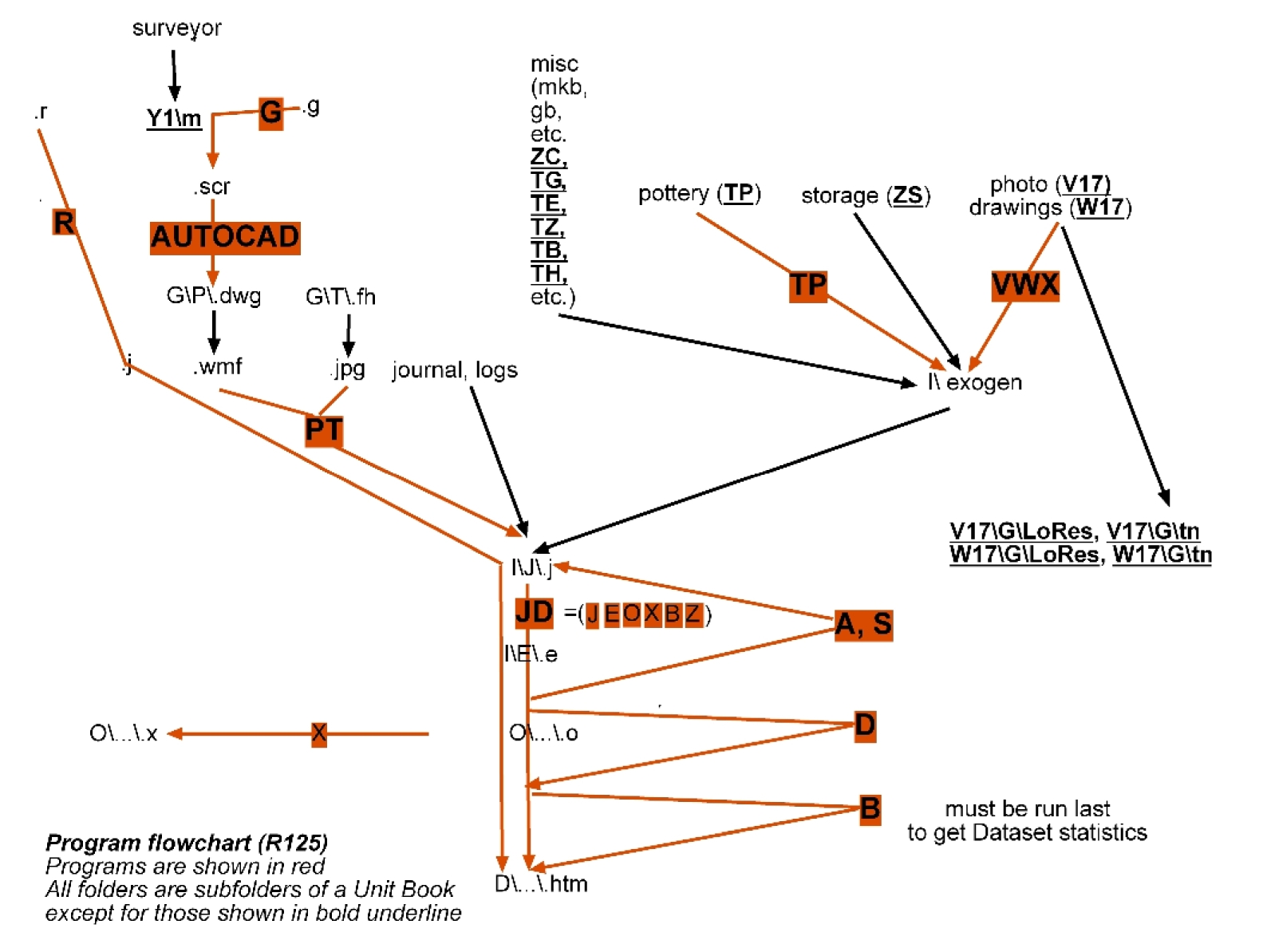
The BASIC programs were divided into two major groups, the Intra-unit, and the Extra-unit Programs.
The former are restricted to a given excavation unit, and thus are primarily tied to stratigraphy, while the latter deal primarily with typology. They are shown diagrammatically in the chart to the right.
|
|
|
Back to top: Project's history: the Sites domain
Primary programs: the JD suite
The core set of programs deals with the journal and log type of input: it is structured in ways that correspond to normal data entry, but with a set of codes that make it possible for the data to be processed and integrated into both the browser format and a database format. This is expressed in the label JD, which stands for the process going from “Journal to Display” formats.
The input is suited both for stratigraphic and typological analysis: it is therefore used both at the time of excavation and in all subsequent phases of analysis in the laboratories of the Expedition house or away from a field situation.
The JD suite includes programs that process data a an intermediary level, in particular the programs A and S that create respectively the output relating to assemblages and strata.
The JD suite produces two basic types of output. The main one (D) is the display version, in HTML format, suited for the browser edition of the data. A secondary one (J) is the ordered version, in plain ASCII, that is identical in content to the D versions, but is not formatted, and thus serve as a database for future, different applications.
Upstream of the JD suite other programs produce outputs suited for implementation by the JD suite, in four main areas, as follows.
Back to top: Project's history: the Sites domain
1. Surveying data (M, R, G and PT)
The surveyor produces a set of benchmarks (M) that are used to triangulate stationary features and movable items.
The result of triangulation is recorded in the form of relays (R) that are in turn integrated into the final output by the JD suite.
The G program processes triangulation data and prepares them for processing through the commercial program AutoCAD.
The PT program integrates Plots and Templates into the system by creating files that link to the proper graphic file and can be in turn processed by the JD suite.
This type of data will be replaced by an adaptation of the GPS system.
Back to top: Project's history: the Sites domain
2. Typological analysis (TP)
Ceramics is the only category of items for which I developed a program (TP for “Typology of Pottery”). The input is in the form of more complex spreadsheets (or logs) than the ones used in the field. It represents the many categories that are needed for a proper analysis of ceramic types, and it creates journal type files suited for processing by the JD suite.
Similar inputs and programs were expected to be created for other typological categories, such as human remains or figurines, but were not implemented yet.
Back to top: Project's history: the Sites domain
3. Graphics: photography and drawings (VWX)
Photographs and drawings are stored in separate folders, divided by season. This program creates appropriate indices (V stands for “Views,” W for “draWings,” and X for “indeX/indices”) that can be also used by the journal files processed by the JD suite, so that photos and drawings can be linked with a thumbnail given within the text. It selects applicable photographs, drawings, and other images from the pertinent V and W folders and formats them for display. It produces an intermediate file for the JD program to process.
Back to top: Project's history: the Sites domain
4. Storage (ZSB)
This program analyzes the input from the storage area and from list if items sent to the museum, and produces input files for the JD suite, adding, for each item, the appropriate information in both the “Display” and the “Ordered” versions (D and O).
Back to top: Project's history: the Sites domain
1983-84: The plotter
Back to top: Project's history: the Sites domain
An early achievement
One of the remarkable results that could be obtained even with these primitive methods was the possibility afforded by a flatbed multi-color plotter to draw on paper floorplans and more that had been defined numerically in terms of coordinates taken in the field.
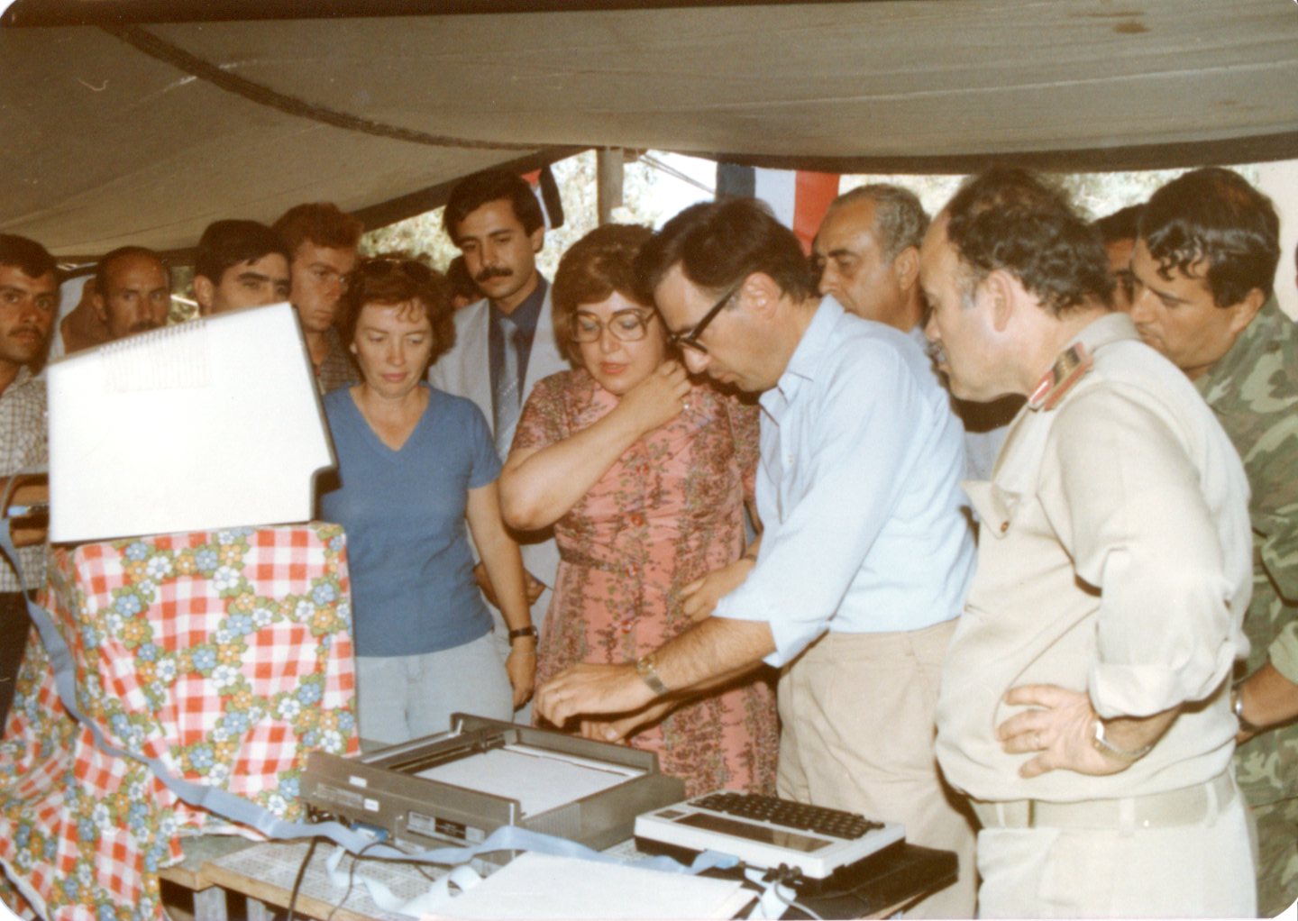
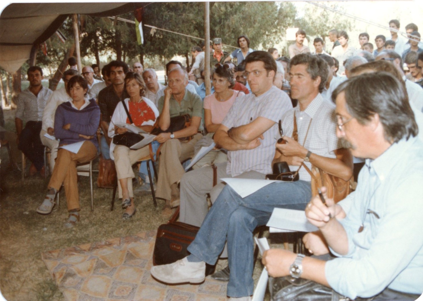
The images to the right, both taken by Anwar Abdel-Ghafour, refer to a presentation given in Ashara (the town where Terqa is located) on the occasion of a Symposium held in Deir ez-Zor for the 50th anniversary of the start of excavations at Mari. We had invited all participants to visit the site, and we held a demonstration of the computer system in the courtyard of the local school.
The top image shows the then Minister of Culture, Dr. Najah Attar, viewing the plotter, which is operated by the small Tandy 100 on the side, and is linked to a monitor in the upper left.
The lower image shows some of the participants in the event, notably some of the major scholars in Mesopotamian studies; from left to right, Horst Klengel and Evelyn Klengel-Brandt, Jean-Claude Margueron, Mirjio Salvini and Paolo Emilio Pecorella in the front row.
|
|
|
Back to top: Project's history: the Sites domain
An anticipation of GPS and GIS
Plotting was a very visible practical implementation of the hidden potential of digitality: it was in effect a premonition of what the "Global Positioning System" and the "Geographic Information System," which were eventually made possible on a much large scale and with much easier tools.
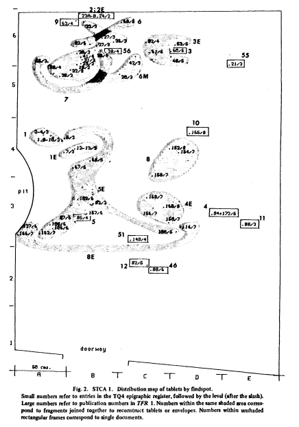
As an example, we may look at the distribution of tablets and tablet fragments from the archive of Puzurum, which I published in the introduction to Olivier Rouault, L'archive de Puzurum, Bibliotheca Mesopotamica 16, Malibu: Undena Publications, 1984, esp. pp. ix-xiii.
The image to the right gives an overall view of the room where the archive was found. Each number on the plan refers to a fragment, while numbers enclosed in a rectangle refer to a complete tablet. The shaded areas enclose items that turned out to be fragments of the same tablet or envelope.
The image below gives a view of a portion of the same floor plan, to which I append a more detailed analysis.
|
|
|
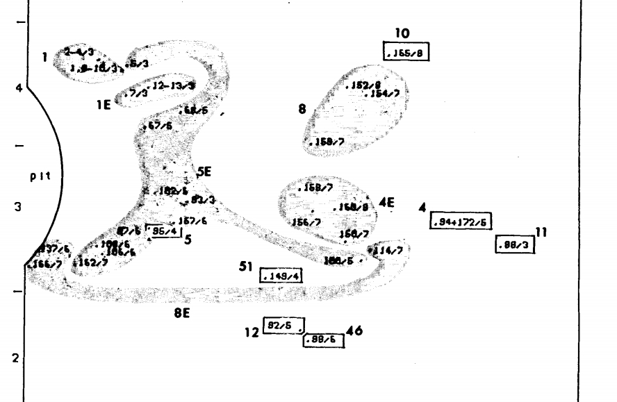
Tablet 5 was found intact: its location is shown with the rectangle that gives the field number (86) assigned at excavation time, followed by the indication of the level (4) which corresponds to an arbitrary layer of 10 cm between elevation 1129 and elevation 1119, see p. xiii). The shaded area includes eleven fragments of the envelope (5E), with the location given for each fragment, contained between levels 3 and 7 (elevations 1139-1099, i.e., 60 cm in depth).
Stratigraphic analysis tells us that the envelope had been broken before being deposited, but not the tablet. Both tablet and envelope fragments were then thrown in a room that had already an accumulation of other material, and the fragments of the envelope were scattered in an area next to the tablet, at different elevations because the preexisting deposit was uneven.
The implications are very significant:
- We may safely infer that the document had been opened in front of a judge to ascertain its authenticity. It was then discarded (not properly "archived") in a storage area, where other items had been placed somewhat haphazardly.
- The date of the tablet refers then not to the moment when the building was abandoned, and we cannot even tell whether it refers the building where it was found.
- Since all the epigraphic finds refer to the same individuals, it is likely that this group of texts was originally indeed an "archive," even though it was not properly "archived" in the room where we found it.
Back to top: Project's history: the Sites domain
Open access (AFP)
The program (AFP for “Archaeological Floor Plans”), written in BASIC, was published in G. Buccellati and O. Rouault, “Terqa Preliminary Report, N. 12: Digital Plotting of Archaeological Floor Plans,” Computer Aided Research in Near Eastern Studies 1/1, pp. 3-40, which also used the archive of Puzurum as an example (see especially Figs. 3-5).
This article was an early experiment in what came to be known as “Open Access,” see especially p. 6: “The scope of this article is primarily practical. We wish to make available the methods and techniques which would enable field archaeologists working in similar conditions to utilize the same system. […] It must also be noted that we expect a minimum of acquaintance with programming in BASIC; however, rather detailed explanations of the program are included, so that users with even a small amount of programming experience may be able on the one hand to use the program as a selfteaching device, and on the other to easily enter general improvements or specific modifications to suit their own particular needs.” The program was printed and was potentially available electronically – but the only medium available at the time was … a cassette tape!
For an analysis of these early experiments see G. Buccellati, “A Discipline in the Making. The Terqa Digital Experiment,” forthcoming in AAAS (Annales Archéologiques Arabes Syriennes).
Back to top: Project's history: the Sites domain
1992-98: Static outputs
What we had experienced in Terqa with the plotting procedure, did in fact address a central issue that lurked behind the whole enterprise: what can ultimately be the fruition of a digital project? Concretely: what kind of output can be obtained that may be “published,” i.e., made effectively available to scholars? At that stage, we were experimenting with floppy disks for the textual domain, but in point of fact this solution had never become editorially viable; in other words, there were no scholars interested in obtaining them. It was the same in the case of the excavation material from Urkesh.
Back to top: Project's history: the Sites domain
Excavation units
We did prepare excavation reports in floppy disk format: as an example, here are printed pages from the features and the items sections of a 1992 version of unit A6:
In 1998, we prepared a version of unit OH2 on a compact disk, which was illustrated in a PowerPoint presentation, included in the current version of OH2.
But these were static outputs: they were as if asking for a dynamic format – which became possible with the introduction of a browser edition, as found in a website.
Back to top: Project's history: the Sites domain
Typological books: Ceramics
Besides the unit books, several versions of typological books were prepared. It was planned to publish them in a paper edition, but this did not materialize as were working towards the kind of digital publication that is now being implemented.
The one about ceramics underwent a number of different iterations, and we will give here an example from two versions.
The first, from 1992, gives the analysis of the ceramics found from the third to the fifth seasons.
We see below the first two pages of the introduction,
then two pages of the detailed ware description relating to the Coarse Pebble Tempered ware,
and finally a page with the shapes of the Chaff Tempered ware.
The second example is from the 1997 Manual, which covers the ceramics from the Royal Palace.
Here, too, one can see the two brief pages of the introduction and a sample of the shape pages.
These examples are, it goes without saying, of the type that is common with any excavation project. They are given here because they show the origin of the categorization process, based on rosters and lexica, that grew into full maturity with the digitalization process of the Urkesh Global Record.
Back to top: Project's history: the Sites domain
Typological books: Glyptics
Another type of typological book that was developed was the one about glyptics.
For a description of the early Urkesh glyptic catalogs see the section under the domain Seals.
Back to top: Project's history: the Sites domain
PHASE III. BROWSERS (1997-2011)
Back to top: Project's history: the Sites domain
1997-2002: LAN and graphic interface
The two major innovations in technical terms were the introduction of networking and of the Graphical User Interface.
(1) Networking meant of course the World Wide Web, but the principle applies at any level, and in our case it meant having a Local Area Network at Mozan well before the internet reached the site. This was implemented by Federico Buccellati as early as 1999; see the brief report in an article published in MDOG 132, section 11 on pp. 161-63.
The conceptual import of the LAN system was very significant: it meant that there could be an effective coordination of all areas of work, from the individual excavation units, to the specialized analysis in the labs of the Expedition House.
(2) Similarly, the Graphical User Interface capabilities served as a major step forward. Technically, we came to rely quickly and exclusively on digital photography, and at the same time scanning of hand produced drawings became an essential component of the system. This meant that visuals could be integrated on a digital page creating an immensely richer vehicle for communication. See in particular the 2001 article by Federico Buccellati on Digital Photography.
The conceptual dimension was brought out in a 2006 article on architecture and a 2008 article on ceramics.
Back to top: Project's history: the Sites domain
Privileging excavation units
An important decision that undergirds the entire system was to privilege the record of the individual excavation units. This is based on the fundamental principle that the objective record is tied not to the entities that can be understood and defined typologically after (generally long after) the excavation has been concluded (a house, a temple), but rather to the typologically nondescript areas that are defined purely on topographical grounds, before anything is known about the nature of the deposition.
The goal is to publish the entirety of the observations made in the course of the excavations, often over a period of several seasons of work, and to articulate the presentation in such a way as to make it coherent in its structure. The data are not given in the format of a daily journal, nor of a data base, even while they retain both of these aspects. Rather, they are embedded in a structured organic whole that reflects the process as much as the result of the excavation.
This came to mean that each excavation unit would have its own website, or digital book. And these websites would serve as the key building blocks for all subsequent analysis and type of publication. These different types of websites are briefly described in the following section.
Back to top: Project's history: the Sites domain
2000-11: Websites
What networking and graphic interface made possible on the hardware level, browsers made possible on the software level: a fully dynamic interaction among levels of analysis. Pinocchio-like, the rigid format which I had constructed became alive.
The website appeared as the natural embodiment of the static outputs that had been developed in the earlier stages of the project. These “digital books” appeared to be as if websites in nuce, and the coordination among them emerged as part of a larger digital architecture that could fully exploit the potential now being unleashed.
This ten year period before excavations were interrupted by the war provided the opportunity for testing and refining the format of the websites both in the field and in the periods between seasons: by the end, this format was finalized in the manner which I will here summarize briefly.
Back to top: Project's history: the Sites domain
urkesh.org
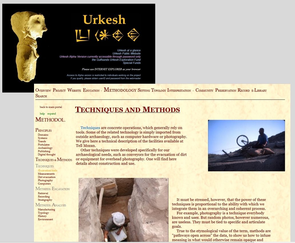
By 2004, the website urkesh.org was set up as the main frame within which the individual digital books regarding the excavations would be clustered. The image shown here with black background is the original homepage. The current homepage has been modified to include other aspects of the project.
The top menu bar refers to descriptive sections, such as one on METHODOLOGY, where number of subsections are found, dealing with various aspects of the project, e.g., Techniques and Methods.
|
|
Back to top: Project's history: the Sites domain
Urkesh Global Record (UGR)
The section of urkesh.org entitled “The Record” serves as the hub for individual books devoted to specific sectors of the field work.
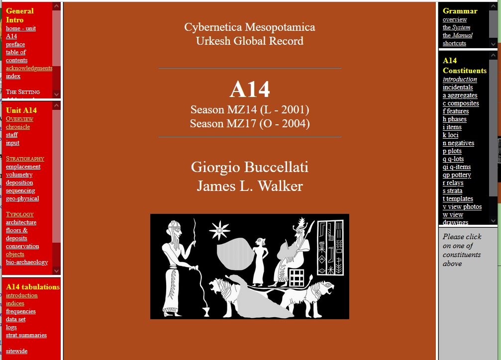
These digital books are listed on the left-hand side bar, each one being briefly described – as in the case of the digital book of the excavation unit A14.
Back to top: Project's history: the Sites domain
Types of digital books within the UGR
There are five types of digital books within the UGR, subdivided into two major groups, as follows:
EXCAVATION
- Excavation units
- Functional and topographical areas
- Sitewide
TOPICAL
- Typological
- Methodological
These five types are briefly presented below.
Back to top: Project's history: the Sites domain
1. Excavation units
The format is uniform for all unit books. The two side bars serve as the main table of contents for the whole book.
The left-hand side presents a synthetic overview of the excavation unit, situating it in the wider context of the excavations.
The right-hand side presents an analytical view of the material for the unit: it is in effect a database, where the data are given in both a narrative and a spreadsheet format.
|
|
Back to top: Project's history: the Sites domain
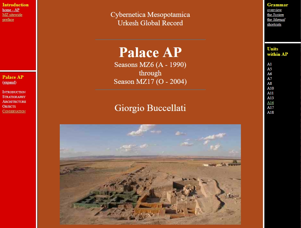
2. Functional and topographical areas
The boundaries of individual excavation units were set arbitrarily, in the sense that they were defined before excavations would make clear the actual cultural context and its stratigraphic history. Once this context and history became apparent, new digital books would gather synthetically the documentary material of the corresponding unit books. The one about Palace AP is an example.
Similar books are also projected for larger topographical areas, e.g. AA.
|
|
Back to top: Project's history: the Sites domain
3. Sitewide book
The Mozan sitewide digital book presents the larger picture of the excavations, with synthetic overviews and indices of the major categories of finds.
It also deals with organizational aspects of the project, in particular with regard to the sequence of seasons and details about the staff.
This website differs from the parent site urkesh.org because it is geared to the specific and technical aspects of the excavations.
|
|
Back to top: Project's history: the Sites domain
4. Typological books
Ceramics constitute the largest body of items found in the excavations, close to a million registered vessels and sherds. The digital book contains a comprehensive analysis of some 300,000 items, from all excavation units, organized according to a detailed categorization system that is fully expounded here.
For a more synthetic overview see the main Urkesh website. |
|
This is the first typological book to be completed, and will soon be archived in this version. Other books are in preparation, both for items (glyptics, figurines, metals) and for given aspects of the excavation ( such as conservation).
Back to top: Project's history: the Sites domain
5. Methodological books
The Grammar digital book presents the theory and the practice of the UGR system.
In the current version, it includes also a brief description of the programs as they were first established in the 90's. We expect a new methodological digital book to be devoted entirely to the new Python programs.
|
|
Back to top: Project's history: the Sites domain
2003: Spatial technologies
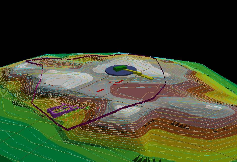
Results of virtual reality project: high mound with palace and temple
Back to top: Project's history: the Sites domain
Forte, Dell’Unto and F. Buccellati project
In 2003, during the 16th season of excavation, an intensive study period by Maurizio Forte and Nicolò Dell’Unto resulted in a highly promising pilot project concerning virtual reality and a reconstruction of the paleo-environment. Work focused on the palace (with digital photo rendering), the objects (in particular, a cuneiform tablet, rendered three-dimensionally), a broad and intensive analysis of the tell in its modern configuration with the ancient buildings sown as well.
A comprehensive article was published in 2005 (F. Buccellati, M. Forte and N. Dell’Unto, “TheTell Mozan/Urkesh Archaeological Project: an Integrated Approach of Spatial Technologies”). After an overall presentation of the site, the article describes the concept of browser edition and then presents five major results of the project.
Back to top: Project's history: the Sites domain
A browser edition
The text describes in a few words the approach described here in the preceding section, addressing as follows (in an article dealing with high level technology) the merit of the low level approach we have chosen:
What is important about how we collect data is that the
source is always an ASCII file - the dumbest, least
technological file format available. But precisely because
of its simplicity we hope it will survive the problems
inherent in technological innovation. All of us have
probably had files that we could not read immediately
because they were saved in an older format, and perhaps
still remember programs that were the standard of the
moment but have ceased to be supported at all (Wordstar,
Dbase)
Or again the description of our program as a
piggyback program - all the data remains in
ASCII and JPG formats, so that as HTML dies, we lose
all the work put into creating this program- but none of
the data.
Finally, a description of the hardware issue:
The
exponential growth of technology is impressive, but the
fact that no physical media format that existed in 1984
still exists in computers today is disconcerting; for
example, the Tandy 100 used a cassette drive, CP/Ms
used 8” drives and 5!4” drives were the newest on the
market, and were also the last floppies to actually be
‘floppy’. Apart from the problem of media, no file written
in 1984 can be read by a modem computer with the
exception of ASCII-based files.
Back to top: Project's history: the Sites domain
Integrated approach: virtual heritage
An extensive explanation of how to integrate a diversity of techniques within a coherent research framework, which could be implemented within the Urkesh Archaeological Project:
we think that the construction
of a spatial virtual reality system dedicated to the
investigation of the ancient Urkesh can constitute the
beginning of a new challenge for the archaeological
methodology, passing directly from the fieldwork to the
virtual reality, from the scientific domain to a collective
communication, keeping all the data within the same
interactive environment.
The major aspects are described in detail (see the next five points). We were making plans for the implementation of at least some of them when the beginning of hostilities in 2011 made it impossible for us to continue.
Back to top: Project's history: the Sites domain
Remote sensing applications
A detailed study of three multispectral and spatial images (Corona, Landsat 7 and SPOT focused on the Outer city wall, and the results are thus summarized:
Comparing in overlay all the traces identified on the three
satellite imagery, it seems that the defense wall is of
circular shape with a perimeter of about 4500 meters. The
other traces and anomalies identified in particular on the
Landsat imagery could belong to other defense walls,
maybe concerning the evolution of the settlement.
Back to top: Project's history: the Sites domain
DGPS survey
The Differential Global Positioning System as supported by Landstar System is described. The experiment was focused on the Temple area, and it showed
enhanced several micro traces mainly in the
southern side [...]. The presence of these evident traces can suggest a wide monumentalization in the area of the
temple, maybe for isolating and emphasizing the sacred
building.
Back to top: Project's history: the Sites domain
Virtual reconstruction of the archaeological landscape
Knowledge and diachronic interpretation of an
archaeological landscape depend on factors of
perception, self-referring, interaction (“feedback”) and
cultural learning. Therefore for interpreting the landscape
we have to create the “map” in Batesonian sense (“The
map is not the territory”), the map is the virtuality, the
“difference”, the territory is the reality.
Back to top: Project's history: the Sites domain
Photo modeling and digital processing
3D modeling, which has become commonplace in the meantime, was at the time an early experiment, which was carried out on a building (the Palace) and an object (a cuneiform tablet). The article describes the operational details and illustrates the results.
Back to top: Project's history: the Sites domain
2008: An Archaeological Grammar and a Global Record for the Monumental Urban Complex of Urkesh (Mellon grant)
This was a two year project which served as a major role in providing the transition between Phase III and Phase IV. We were at that point defining both the theoretical and the practical aspects of the project, and the reference to the “Grammar” and to the “Urkesh Global Record” indicate clearly what our goals were. I give here the full text of the proposal, and I will mention a few distinctive points.
«Publication will be innovative methodologically because it introduces a wholly new approach to digital thinking and publishing. Explicitly formulated as a theoretical model, there is at the same time a direct practical impact because the system allows for a full exploitation of the data during, and immediately after, excavation. The core principle of the system is that each field record is construed in its entirety as a script through which a full fledged browser edition is automatically produced on a daily basis.
The proposal explains briefly how the project is meant to provide an answer to the vexed question of archeological publishing, or non-publishing as the case may be. It is suggested that the chronic delay (often resulting in the total non-appearance of final reports) derives from deep-seated intellectual presuppositions rather than from practical or other factors. Discussed in this proposal is how I plan to apply a novel understanding of what an archaeological publication should be, and how the experience gained over the years will serve us in good stead in order to meet our goals. A preliminary version of two earlier volumes of the Urkesh Global Record is available for inspection online.»
The two major results were the closing of A16 as a completely finalized digital book (2009), and (in 2017) the publication of the book A Critique of Archaeological Reason.
The final report, sent in March 2013, gives an exhaustive account of the work done, and it shows the growing awareness for the implications of the system as conceived and implemented.
Back to top: Project's history: the Sites domain
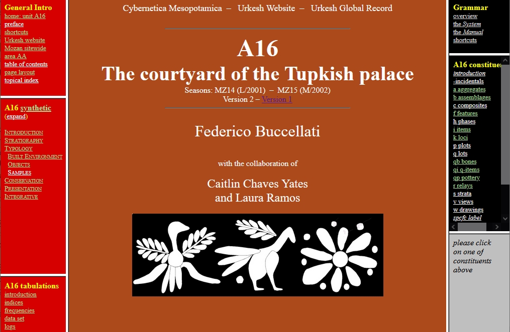
2009: The A16 digital book
|
The digital book for unit A16 served as the model, and the 2009 version was crystallized as the first example of an archival version. The other books followed the same pattern, and thus a sizeable cluster of websites, or "digital book," came into existence -- although none came during his period to be quite as complete as A16. They were listed in the homepage of the hub website urkesh.org and in the section of the same website dedicated to the Record.
|
|
Back to top: Project's history: the Sites domain
PHASE IV. AN INTEGRATED SYSTEM (2012-21)
Back to top: Project's history: the Sites domain
2012: The digital invention of Urkesh (NEH proposal)
I prepared a major proposal for NEH (National Endowment for the Humanities), which anticipated the substance of what we are aiming to do now within the Cybernetica Mesopotamica project. The application was rejected. It seems valuable to include it here because it shows how deeply rooted the conceptual structure of the project is. I refer here only to the abstract, the narrative and the appendix. I also include some of the reviewers’ comments, which, in my view, indicate that there was little understanding of what I was planning to do.
See for instance this statement from the abstract:
«Intellectual goals. – We aim to make the website a model of its kind, for the completeness of the documentation and the manner of presentation. A strong theoretical dimension underlies the system, and the website is both a channel for the articulation of the principles and a full-fledged test case for their application. As we see it, the completion of the website is not only an accomplishment in terms of archaeology, but a statement about the quality and ultimate goals of digital publishing.»
It should also be said that there was ample graphic documentation of what the project entailed, which, in my estimation, was adequate in showing how fully structured the digital publication in the form of a website was already completed.
The proposal was rejected, and it is particularly interesting to read some the negative comments which seemed to miss the central goal of the project:
«[...] it is unclear from the proposal how this website and its related utilities function offer something new that could not be created from a standard database linked to a website.»
«My feeling is that interpretations are mutable, data is forever. That is, the interpretations of one should be recorded and held to scrutiny, but it's the underlying dataset (and parameters related to its retrieval and quality) that require focus in terms of curation. The PI seems to argue for the preservation and curation of the argument. I'm more concerned with data archival.»
These comments suggest that the “standard database” approach is preferable, and that arguments do not deserve being “archived.” The aim of the project, as presented in the proposal, was precisely to do what is here cosidered as irrelevant: a website was seen as the proper place to embed argument and database in a single integrated system. One reason why these reviewers’ objection would, today, seem invalid is because of the vastly growing impact that websites have on the communication of knowledge – in other words, the greater recognition of the website as a valid, if much more complex, epistemic system. Which was what was being proposed then.
«The example website uses very old html - the use of frames is pervasive in the example which have not been recommended WWW3 HTML for over a decade.»
«[It] would encourage the development team to reach out and explore contemporary fully developed content management systems and development languages»
«QuickBasic? Perl? Unfortunately the reality is this project needs a technical consultant who
understands the recent developments to put this into a better programmatic and data framework.»
The proposal was aimed precisely at doing what is being suggested. From the tone of the comments, it looks as though we were planning to use QuickBasic. What is missed is that QuickBasic was used in the 80es and 90es in such a way as to allow a smooth correlation between the data as such and their “management.” Similarly, the use of frames in the browser version was at the time the best way to implement what I considered an important conceptual goal, namely to have the overall structure of the website present at any time. It was more than obvious that both QuickBasic and frames had to be replaced, and that was precisely the goal of the proposal. But what had been achieved and really mattered, and what seems to have been overlooked by the reviewers, was the fact that the website as conceived served as a functioning whole – again, a proper and new epistemic system.
Back to top: Project's history: the Sites domain
2016: 3DVA. F. Buccellati, Volumetric Analysis
The publication of
Federico Buccellati,
Three-dimensional Volumetric Analysis (3DVA) is a milestone
in the history of
Cybernetica Mesopotamica,
deeply rooted in the
larger framework
and yet wholly independent.
|
|
3DVA marks a real turning point in Cybenetica Mesopotamica for number of reasons.
Back to top: Project's history: the Sites domain
1. A new methodological use of a technique
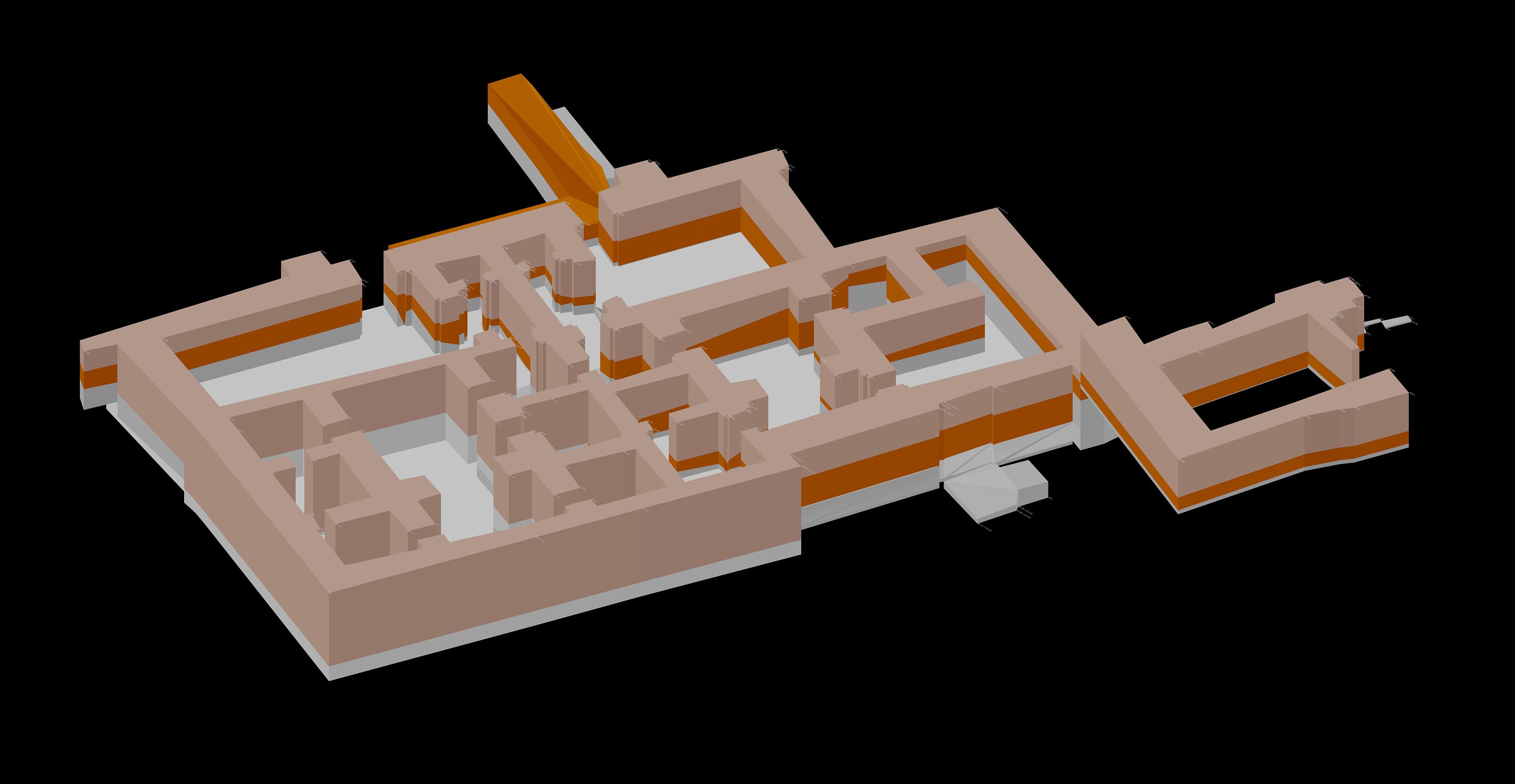
3DVA brought together a large amount of data from the excavations, based on a number of excavation units, presenting them in their susbstantive complexity and, at the same time, articulating a wholly new method of analysis: a three-dimensional rendering of a building was seen as applicable not just to the architectural volume as projected, but also to the actual volume as excavated.
Back to top: Project's history: the Sites domain
2. Documentary function
Drawing on data from the Urkesh Global Record (UGR), 3DVA produced an analytical tool designed to be used not extrinsically, as an after the fact reconstruction, but as a documentary tool, because it shows the actual contours of walls as excavated (brown and grey in the image above).
Since the program is integrated in the UGR main system, it can be applied to the data as excavated on a daily basis, thus showing the excavation in progress, on any given day.
Back to top: Project's history: the Sites domain
3. Heuristic function
This intrinsic quality of the program, i.e., the fact that it can be used not as a deus ex machina after the end of the excavations, but rather daily within the course of the excavations and using data that are already gathered as part of the normal URG record, has an important impact on strategy. It allows in fact to see right away what the projected effect of further excavations might be, based on the solid evidence available at any given moment in time.
Back to top: Project's history: the Sites domain
4. Aesthetic function
While emphasizing the utilitarian aspect, so to speak, of the approach, it is clear that the aesthetic effect is by no means secondary. The projected reconstruction (in beige in the image above) gives a very well defined view of the architectural complex in its totality, quite similar to that of standard three-dimensional programs.
This aspect is brought out especially through a very remarkable walk-through sequence included in an early film on Urkesh (at minute 18:10) – remarkable not only because of the effect, but also because of the date, around 1996 (see also F. Buccellati 1998).
Back to top: Project's history: the Sites domain
5. Integration
The publication of the volume is significant because it reflects the commitment to integrate digital and print versions. This applies not only to the fact that the book was published immediately as a dual edition.
More importantly, the volume gives in printed format not only the visual rendering of each wall of the palace, but also the alpha-numeric input behind it. At the same time, there are links to both the program and the data.
Back to top: Project's history: the Sites domain
6. Two programs
See below for the program that generates the three-dimensional output (BlockGen).
Another aspect of 3DVA was its connection to experimental archaeology through a study of the production of mud bricks needed for the physical reconstruction of some walls, which is studied in detail in the published volume. Starting from this work, the project evolved into a new program, EnCAB, which introduced yet another aspect of the research connected with the excavations: the assessment of the economic and social dimensions that go along with the construction of any structure, especially of large public buildings.
Back to top: Project's history: the Sites domain
7. Nature of programs
These programs are original in both conception and implementation. They do not simply apply existing visualization techniques, extrinsically, to a given set of data. Rather, they develop a wholly new concept – the actual contours of a wall as excavated in one case, the relationship between volumes and costs on the other.
They are self standing and yet they are integrated within the larger framework of the Urkesh Global Record conceived as a comprehensive approach to the excavation process and its record.
Back to top: Project's history: the Sites domain
2016-21 Programming
Back to top: Project's history: the Sites domain
2016: BlockGen: Volumetric record of in-progress exposure of architecture (AutoLISP)
The presuppositions for creating the program are explained in F. Buccellati 2016 through the analogy with a UFO:
-
«A good metaphor for this situation is that of a UFO 'visit': a team whose skills are nearly incomprehensible to the locals arrives, collects a lot of data and asks a lot of questions, then after few days departs, never to be heard from again, leaving a nearly magical final product behind. How this product came to be is unclear to the locals, and its use is very limited vis-à-vis the functionality it would have in the hands of one of the 'aliens'.
This is of course a tongue-in-cheek analogy for what goes on, but it serves to highlight the problems: the lack of interaction between the modeling team and the archaeologists, and the lack of understanding as to how to manipulate the final product and use all of its potential within the archaeological process.» (p. 202)
Instead,
-
«The key point is that what is being proposed is not a way of creating a model to 'look at' extrinsically instead a model which is a real tool for archaeological research in the field.» (p. 212-13)
The program (designed by F. Buccellati and written in AutoLISP) accomplishes exactly this need for an “intrinsic” approach, as is fully demonstrated in the volume cited, and it represented a major new development in the progress of the system. It is now fully documented and publicly available at
this link on GitHub.
Back to top: Project's history: the Sites domain
2018: CerPhaS: Tabulations of ceramics by multiple variables (Python)
The program, designed by Laerke Recht and written by Bernardo Forni, produces extensive tabulations within the Urkesh ceramics digital book, in the form of:
Methodologically, the program was significant because it did for movable items what the DVA programs did for architecture: elaborating the data for further enrichment of the website publication of the material.
Back to top: Project's history: the Sites domain
2019: EnCAB: Energetic Calculator for Ancient Buildings (Python)
This is a major independent, ongoing project, which falls directly within the purview of Cybernetica Mesopotamica for two reasons: (1) it originated with the work on the Palace of Tupkish (F. Buccellati 2016, ch. 3), and (2) we intend to actively pursue its development within the framework of our project.
Wide ranging in scope, it applies universally to all regions of the world, and it incorporates already a vast library of documented conditions drawn from archaeology and ethnography. See F. Buccellati 2019 for an effective demonstration of its potential. In this regard, it shows the wider reach of the work done within our project.
The program was designed by Federico Buccellati and written in Python by Bernardo Forni.
Back to top: Project's history: the Sites domain
2019: Perl rewrite of PA
The goal of rewriting the programs (originally in QuickBasic) and providing a new platform (originally DOS) was delayed because of the lack of success in obtaining the NEH grant. With some special funding obtained in the meantime, we asked Massimo Maiocchi to rewrite the original suite, and he chose Perl as the appropriate language. The project was successful, and in the following years the new program was used on a regular basis in processing the old data.
The Perl rewrite reproduced faithfully the original program, with no substantial changes in the output, so that the resulting websites are practically indistinguishable.
Back to top: Project's history: the Sites domain
2021-23: Python rewrite of PA
While the programs as rewritten in Perl functioned as intended, it soon appeared that Python was better suited for the production of new websites and in general for the management of the UGR. Bernardo Forni took on the task of rewriting the PA suite and to produce new programs for the organization of new websites, beginning with those for the bibliography domain. The rewrite of the PA suite was a major goal in the project, and in the process a new program was added, MID, that replaced DABI.
A full program description will appear in the topical digital book Python programs documentation, by Bernardo Forni. Here I will only give a brief synopsis, to which one should add CerPhaS.
Back to top: Project's history: the Sites domain
Programs in Archaeology (PA)
- The JD suite. – The new JD suite incorporates all the various programs that were originally run independently, especially the R and the TP programs. The new Python program obviously runs faster. It can be run independently in the field and in the laboratory without the need of internet access. An additional new feature is that it can be run directly on the server, so that constant updates are easily done literally from anywhere in the world. (The surveying programs will no longer been needed in the field as one will use direct input from GPS instruments.)
- The VWX program. – The new VWX program also works independently on a user's computer or directly on the server.
- Remaining programs. – Besides a few minor corrections that remain to be implemented, an important additional feature of the JD program is the production of sitewide indices. A long-term goal will be a comprehensive search program.
Back to top: Project's history: the Sites domain
From Markdown Input to Display (MID)
The DABI program has been reworked so as to incorporate the production of the left-hand side of the UGR output files. The new MID program will also have to be extended to process the files for the urkesh.org website.
The MID program makes the input of discursive HTML files much easier to produce.
Back to top: Project's history: the Sites domain
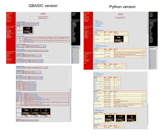
Changes in the output
- Frames. – The new programs eliminate the use of frames so that links can be more easily produced to display the whole page, with all relevant side bars.
- Format. – The UGR format has been improved with each section highlighted by a distinct background color, see, e.g., A16.6 in both the QBASIC (A16.1-1) and the Python (A16.1) versions, which can be visualized side by side as follows:
- A filter in the long lost of constituents (lower part of right hand sidebar) make it easier to reach the desired query item.
- Error trapping – An extensive error trapping routine has been added, which will make it easier especially in the field to maintain the date up to date.
- Search. – A full search function has been introduced, as in this website (top of the leftmost sidebar)
- Topical index – Similarly, a select topical index has also been introduced.
Back to top: Project's history: the Sites domain
2020: A manual for the beginners
As new contributors were found to work on the UGR, it became apparent that it was necessary to have an introductory manual that could prepare new recruits to work on the old data and process them for inclusion in the UGR. The Manual, authored by Lorenzo Crescioli, is still in the process of being finalized; as an example, one may look at the section about the View Log.
Back to top: Project's history: the Sites domain